Ruta Cuarenta

The Other Great North/South Road in South America

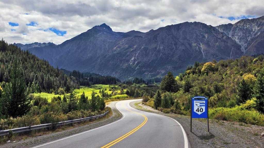
Like the Chile’s Carretera Austral, Argentina’s Ruta Cuarenta (Route 40) is another of the great South American highways. It runs for 3,246 miles (5,224 km) from the northern tip of Argentina where it meets the altiplano of Bolivia all the way to Cabo Virgenes, the most southerly point on the South American mainland. It doesn’t include Tierra del Fuego which is on an island.

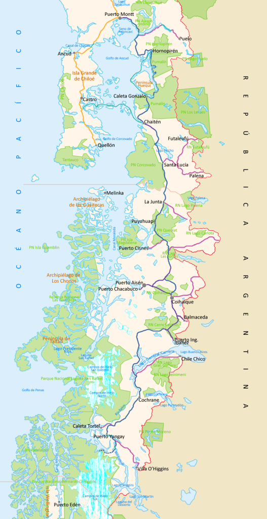
Although I have never been on the Carretera Austral, I have ridden Ruta 40 between Neuquén and San Carlos Bariloche in 1995. Both highways are practically up against the Andes. Where Coyhaique is the only large town on the Chilean highway, Ruta 40 goes through Cafayate, Mendoza, San Carlos Bariloche, Esquel, Rio Turbio, and Rio Gallegos on its way to the large Magellanic Penguin sanctuary by Cabo Virgenes. To go further south in Argentina, one has to take a Chilean ferry across the Straits of Magellan before crossing over to Ruta 3 to Rio Grande and Ushuaia.

There are stretches of the highway south of Rio Negro Province that are not yet paved, being the windy deserts of Patagonia. Even so, a good part of the southern highway is the only land route from Chile’s Villa O’Higgins to Puerto Natales. In addition, there are Argentinian buses plying the route

I would love to take Ruta 40 along its entire length, but I would require an SUV, at least two spare tires, and an auto mechanic. Oh, and for certain areas, a guide. Alas, I am too old and poor to be able to indulge in this travel dream of mine.

The Carretera Austral

One of the World’s Most Scenic Highways

It bears several names: Route 7, the Augusto Pinochet Highway (because it was completed during that dictator’s presidency), and the Carretera Austral , the Great Southern Highway. It runs for 770 miles (1,240 km) from Puerto Montt to Villa O’Higgins. At that point, no roads go farther south. According to Wikipedia:

Carretera Austral has a strategic meaning due to the difficult access by land to a significant portion of Chile’s southern territory. This area is characterized by thick forests, fjords, glaciers, canals and steep mountains. Access by sea and air is also a complex task due to extreme winter weather conditions. For decades, most of the land transportation had to cross the border to Argentina in order to reach again Chile’s Patagonia. These difficulties were deepened during the 1970s due to the Beagle Conflict crisis. In order to strengthen the Chilean presence in these isolated territories and ensure the land connection to the rest of the country, the government planned the construction of this road, which was executed by the Chilean Army’s Engineering Command. More than 10,000 soldiers worked on its construction.

South of Villa O’Higgins is Punta Arenas, Puerto Natales and the Torres del Paine, the FitzRoy Massif, and Chilean Tierra del Fuego—but only after a gap of 225 miles (363 km) of dense forests, raging rivers, and high mountains. Eventually, Chile plans to extend the Carretera Austral south to Puerto Natales, but it will take years. Until then, vehicles have to cross over into Argentina and take Route 40 (“Ruta Cuarenta”) through the windy wastes of Patagonia.

I would love to take the Carretera Austral, but even though the road is paved, many of the rivers (such as the Rio Baker) are unbridged and require time-wasting ferry crossings. Add to that the fact that there are no large cities (except Coyhaique with 45,000 population) along the route if something were to happen to your car.

There’s nothing to stop me from dreaming.

Why Fix When You Could Demolish?

Wiping the Architectural Slate Clean in Salt Lake City

Los Angeles is particularly intent on demolishing its architectural history. And it’s so wasteful when there are so many interesting old building about. I know that many old buildings are not quite earthquake-proof, but they could be made so without driving ugly bolts through them visible from the outside. A classic example is a building in West Los Angeles at the southeast corner of Santa Monica Blvd and Butler. Its rear has a beautiful old mural showing the aftermath of California falling into the ocean “after the next big one.” Unfortunately, the owners of the building have dozens of ugly bolts sticking out of the mural (see below).

Mural Entitled “The Isle of California” with Earthquake Bolts Destroying the Image

This is a typical tendency in California. We know how to build, but we don’t know how to preserve. Instead, we prefer to wipe the architectural slate clean and build something inadequate, with the specious reasoning that we could always ’doze it and start over again in a few years. It’s all part of a larger tend in which we throw up new buildings, but have no interest in maintaining old ones. I for one would love to see the mural above touched up with the bolt heads either covered or removed.

We are not just talking about buildings. Our freeways were so lovely when I moved to Southern California in 1966. Then they started getting rattier and rattier, with ugly potholes. When CalTrans started using concrete to re-pave several freeways, what we got stuck with is an ugly patchwork of variously colored concrete patches interspersed with asphalt, the whole thing looking like a crazy quilt with enough transitional bumps to send your wheels in unwanted directions.

Then, too, are our fast trains that have to go twenty miles per hour because the tracks in many urban areas cannot take higher speeds.

It’s time to consider such things as repair, maintenance, and refurbishment when we look to evaluate our structures and transportation.

A Two-Tiered Highway System

Bus Accident in the Andes

Bus Accident in the Andes

Peru is a major destination for international tourism. It can also be a deadly one. While the nation has improved the highway system connecting such tourist magnets as Lima, Arequipa, Nazca, Cusco, and Arequipa, many large towns in the Andes are linked by roads that are unsafe. This is compounded by the fact that not only the highways, but also the long-distance bus lines, are also two-tiered. A point-to-point Cruz del Sur, Oltursa, or Ormeño bus will generally get you to your destination safely; but a second class bus plying the roads between such cities as Huancayo and Ayacucho takes much longer, picks up and drops off passengers whenever requested, and is likely to have an overtired driver who has been at the job for over twelve hours. When that is combined with night driving, inclement weather, and bad roads, the result can be a fatal accident such as the one illustrated above.

According to the Peru This Week website:

Congresswoman [Veronika] Mendoza has highlighted the inequality inherent in the consistent state of disrepair of roads in rural Peru. “It absolutely cannot be that only roads on tourist routes are in a good condition while the internal transport highways that Cusquenos use aren’t being cared for in the same way,” Mendoza stated, later adding that “We also have to consider the additional difficulty for transportation that the arrival of the rainy season will bring.”

Statistics released by Sutran, Peru’s national government land transport authority, reveal that road deaths have risen dramatically in the past year. According to El Comercio, deaths caused by road accidents from January to August 2013 have risen 36.5% compared with the same period last year.

Many American tourists are interested in following the line of the Andes and visiting the highland cities with their spectacular mountain views and native arts and crafts. While this is not impossible, there is considerable risk attached to such an itinerary.

Photo of Serrano Boy

Photo of Serrano Boy

Part of the problem is that, as in other countries that are racially divided, Peru suffers from racism against serranos and cholos, descendants of the Incas and other peoples inhabiting the Andes. We tend to think of the Andean tribal peoples as being the majority in Peru, but that is not the case: The narrow coastal desert zone holds the majority of the population as well as the economical and political power. The result is that the rural Andes are underserved by good roads and public transportation.

If and when my planned trip to Peru takes place, I will be careful to take the first class buses to major tourist destinations—at least until I have been able to scope out the situation myself.