Mexican Bus Travel Anecdotes

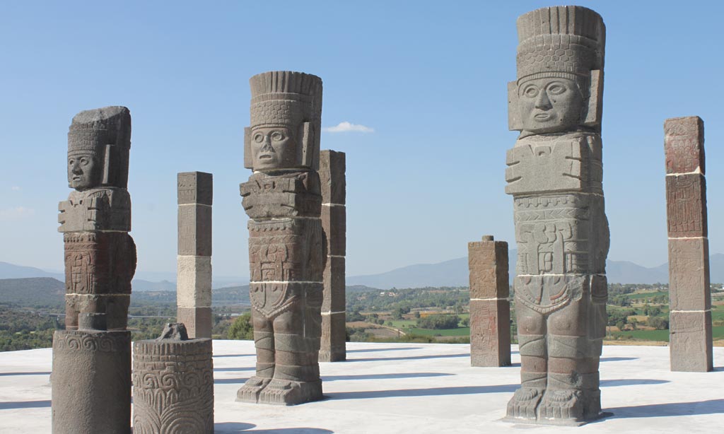
Toltec Ruins at Tula

After yesterday’s post on intercity buses in Mexico, I thought I’d present a few anecdotes about my experience riding the roads of la Republica over the years. For the most part, my experiences were good—though not all. But they were always interesting.

The worst was in the 1980s when I decided to take a bus trip to Tula to view the Toltec ruins there. I had no trouble getting there, but the return trip started on a bad note. While still on the streets of Tula, the Second Class Autotransportes Valle de Mezquital bus I was taking rear-ended a truck. Fortunately, no one was injured, and eventually the driver, ayudante, and passengers were all able to exit onto the roadway. The company was informed and sent another bus to complete the journey to the giant North Bus Terminal in Mexico City.

In 1979, my brother and I took a Transportes Lacandonia bus from Palenque, where we were visiting the Mayan ruins, to San Cristóbal de las Casas. Again, it was a Second Class bus, and the road was nowhere as nice as it is now. On the way, we saw another bus from the same company coming from the other direction off the road ensconced in a ditch. The driver and passengers were standing around waiting to be picked up and complete their journey. We stopped for a few minutes while the drivers compared notes.

On the same trip, near Ocosingo, our bus was stopped by a Mexican army checkpoint. We were near the Guatemalan border, and the army were checking for arms smuggling connected with the insurgency across the border, which was to go on until a truce was signed almost twenty years later.

That same trip, Dan and I took an all-night bus from San Cristóbal to Oaxaca on a first class bus. (I think it was the Cristóbal Colon line.) As we tried to drop off to sleep, we noticed a parade of cockroaches traveling along the base of the sliding windows. We shrugged and nodded off.


Taking Intercity Buses in Mexico

A Bus Ticket from Campeche to Merida in 1984

Americans do not like to take buses. That includes my brother, almost all of my friends and former co-workers. In Los Angeles, the private automobile is king—to the extent that public transportation is seen solely as for bums, crazies, and immigrants. In fact, intercity buses in the United States are mostly run by Greyhound Lines, a British company under the control of FirstGroup; and they do appear to be patronized mostly by bums, crazies, and immigrants.

In Latin America, it’s a different story altogether. If you have ever read Paul Theroux’s The Old Patagonian Express: By Train Through the Americas, you might think that it is possible to travel by rail through Latin America. Although there are a few exceptions—mostly tourist only trains in a few countries—most people in Latin America travel by bus. In many cases, these buses are far better than anything found in our country. In Argentina, I was able to get a good night’s sleep lying horizontally on seats that stretched out. These buses contained clean restrooms, stewards who served free meals, and (negligible) movies in Spanish.

I have traveled some 1,500 miles by bus in Mexico in the 1970s and 1980s. Almost all these buses were manufactured in Mexico and were every bit as good or better than Greyhound buses. This was especially true of First Class buses, which are theoretically direct to destination with few or no intermediate stops. Second Class buses can be hailed anywhere and can be rumbling rat-traps. I can think of the Unión de Camioneros de Yucatán (UCY) buses that I boarded in Uxmal enroute to Campeche in 1984 and 1992.  The windows were broken and the shocks were almost nonexistent, but they did get us to our destination. Some Second Class buses in Central Mexico, such as those of Flecha Amarilla were almost as good as First Class.

Model of an ADO Bus With 1980s Logo

The main First Class bus companies in Mexico include Autobuses de Oriente (ADO), Enlaces Terrestres Nacionales (ETN), Estrella de Oro, and Omnibuses de Mexico, as well as a few other carriers. Note that my ticket above assigns me to a particular seat (#16), and that for First Class buses, I usually reserved in advance by visiting the bus station the day before. With Second Class buses, you just hail them wherever, pay the ayudante (conductor), usually a young man, and take your seat, if you can find one.


The Day Life on Earth Almost Died

A Piece of the KT Boundary

Around the end of July, I wrote a post entitled Revisiting the Cretaceous Extinction. This week, I read a fascinating story entitled “The Day the Earth Died” in the April 8, 2019 issue of The New Yorker. The asteroid that collided with Earth around 65 million years ago was at least six miles wide and gouged a crater about eighteen miles deep and launched 25 trillion metric tons of debris into the atmosphere. The article goes on:

The damage had only begun. Scientists still debate many of the details, which are derived from the computer models, and from field studies of the debris layer, knowledge of extinction rates, fossils and microfossils, and many other clues. But the over-all view is consistently grim. The dust and soot from the impact and the conflagrations prevented all sunlight from reaching the planet’s surface for months. Photosynthesis all but stopped, killing most of the plant life, extinguishing the phyto-plankton in the oceans, and causing the amount of oxygen in the atmosphere to plummet. After the fires died down, Earth plunged into a period of cold, perhaps even a deep freeze. Earth’s two essential food chains, in the sea and on land, collapsed. About seventy-five per cent of all species went extinct. More than 99.9999% of all living organisms on Earth died, and the carbon cycle came to a halt.

This massive disaster left a signature layer across the entire surface of the planet referred to as the KT boundary, short for Cretaceous-Tertiary. (It is also referred to as the KPg boundary after the Tertiary was renamed the Paleogene by geologists.) This boundary layer is high in the rare element Iridium, which is most often found in meteorites and asteroids.

It is a sobering thought that an object from space only six miles across (10 km) could strike the Earth, which is eight thousand miles across (12,900 km) and end up killing virtually all life, and certainly annihilating the human race.

The asteroid collided with the Earth around Chicxulub on the Yucatán peninsula, which I plan to visit, hopefully with a geologist, early next year.

Journeying Toward the Zodiacal Light

Life’s a Journey…

I love this picture from the Astronomy Picture of the Day website. The description of the photo from the website is very technical:

What’s that strange light down the road? Dust orbiting the Sun. At certain times of the year, a band of sun-reflecting dust from the inner Solar System appears prominently just after sunset—or just before sunrise—and is called zodiacal light. Although the origin of this dust is still being researched, a leading hypothesis holds that zodiacal dust originates mostly from faint Jupiter-family comets and slowly spirals into the Sun. Recent analysis of dust emitted by Comet 67P, visited by ESA’s robotic Rosetta spacecraft, bolster this hypothesis. Pictured when climbing a road up to Teide National Park in the Canary Islands of Spain, a bright triangle of zodiacal light appeared in the distance soon after sunset. Captured on June 21, the scene includes bright Regulus, alpha star of Leo, standing above center toward the left. The Beehive Star Cluster (M44) can be spotted below center, closer to the horizon and also immersed in the zodiacal glow.

Actually, the picture means more to me than that. Whenever I travel, I like to leave around sunrise. I imagine the road stretching out before me on the way to my destination. The journey itself is meaningful, almost irrespective of the destination. If I am flying, I make a point to get to the airport hours before the flight, and I make the airport into an intermediate destination, with surprises of its own.

If I am driving, I like the idea of getting out of Los Angeles traffic before most people have woken up. When the sun rises, I like to be in open country, which in the context of Southern California, usually means the desert.

To me, life is travel. It is something of a truism that life’s a journey … but it really is. It is a journey on which we have little notion of the destination. So I resolve to enjoy the journey as much as possible. Who knows what wonders may await us?


Four Travel Classics About Mexico

Fanny Calderón de la Barca’s Life in Mexico (1843)

There are four books written by foreigners over a hundred year period about their encounters with Mexico. They are all beautifully written classics of the travel genre. I present them below by order of publication.

Life in Mexico (1843)

Frances Erskine Inglis was a Scotswoman, herself of noble birth, who married the first Spanish ambassador to Mexico and became the 1st Marquise of Calderón de la Barca. She traveled extensively throughout the Republic and became enamored of the people and their culture. Even now her book is a delight to read and a major influence on writers who followed.

Charles Macomb Flandrau’s Viva Mexico! (1908)

Viva Mexico! (1908)

Next is a book of essays by an American author and essayist named Charles Macomb Flandrau. After a visit to a Mexican coffee plantation run by his brother William, Flandrau wrote Viva Mexico! about Mexico under the rule of dictator Porfirio Díaz who ruled for most of the years between 1876 and 1911. (He is famous for the following quote: “Poor Mexico! So far from God and so close to the United States!) Flandrau’s book is still quite readable today.

D. H. Lawrence’s Mornings in Mexico (1927)

Mornings in Mexico (1927)

British novelist D. H. Lawrence has a mixed record when it comes to Mexico. His travel essays in Mornings in Mexico are among his best nonfiction, while his bloated novel The Plumed Serpent, written the previous year, is one of his worst works, showing no understanding of Mexican Indio culture.

Sybille Bedford’s A Visit to Don Otavio (1953)

A Visit to Don Otavio: A Mexican Journey (1953)

Finally, there is German/British writer Sybille Bedford’s account of a year spent in Mexico, mostly around Lake Chapala, just south of Guadalajara. The Don Otavio of the title is a charming Criollo host who makes the stay of Sybille and her companion at their lakeside estate an idyl. Whenever Sybille attempts to travel to most other destinations (including Acapulco, Mazatlan, Puebla, Mexico City, and Oaxaca), she runs into difficulties. Don Otavio’s estate is like a refuge in a country where travel (at least in the 1940s) was problematical at best.

Interestingly, Bedford is aware of and discusses the other three books mentioned above.


Why Latin America?

There Is a Reason Why I Keep Going Back There

My first vacation on my own—at the age of thirty—was to Yucatán. In the intervening years, more than two-thirds of my international vacations have been to Mexico, Central or South America. Originally, my interest was in Pre-Columbian archeology. I still am, but I’ve added post-Columbian (i.e., Christian) archeology to my interests. The two exist side by side in fascinating ways.

Many Latin-American towns have museums of religious statuary and paintings that used to be in churches that are no longer in service. Lima, Peru, for instance has a fascinating museum in the former Archbishop’s palace adjoining the cathedral.

Sacramental Vessels from Lima’s Archbishop’s Palace

American tourists usually go in for all the pre-Columbian sites, but are totally uninterested in the ruins of Catholicism that are evident all over the place. In places like Buenos Aires; Cuenca, Ecuador; Mérida, Mexico; and Antigua, Guatemala there are old churches that are no longer in use, but there are thousands of items of religious art that are fascinating to me. One of the most incredible is the huge monastery of Santa Catalina in Arequipa, Peru, which is like a walled city in its own right.

The Monastery of Santa Catalina in Arequipa, Peru

In the morning that I visited Santa Catalina, I took the two-hour morning tour. Then I went to lunch and had some rocoto relleno (spicy stuffed Peruvian green pepper) in a restaurant behind the cathedral. Then I went back and spent the whole afternoon actually trying to get lost as I wandered through the narrow streets and saw the chapels, nuns’ cells, gardens, kitchens, laundries, and other services that made up the monastery.

Looking back, I think I’d rather see Santa Catalina again than Machu Picchu. In my mind, they are of equivalent interest, but Santa Catalina is much nicer.


Revisiting the Cretaceous Extinction

This Yucatán Fishing Village Along the Gulf of Mexico Hides a Secret

A few miles from Progreso, Yucatán, is the fishing village of Chicxulub (CHEEK-shoe-lube) which was the site of one of the great catastrophes in the life of the earth. Some 65 million years ago, an asteroid that was nine miles (fifteen kilometers) across slammed into Chicxulub at the speed of 44,640 mph (or 20 km/second) and destroyed some three quarters of all the life on earth, including all the dinosaurs. The impact was equivalent to a million times larger than the largest hydrogen bomb explosion and created a crater that was sixty miles (100 km) across and eighteen miles (30 km) deep.

Of course, that was millions of years ago, and the geology of the area has changed significantly.

Where the Asteroid Impacted


Signs of the Impact Today: A Ring of Cenotes

Today, the Yucatán Peninsula is a large limestone chunk that has been raised up, but with numerous underground rivers and caves admitting access to the water beneath. What you will not find there a river. This did not make it easy for the ancient Maya to grow crops—except in their areas where cenotes prevail. The dark green aresa beneath the ring of cenotes is where the Puuc Hills are located, which rise to an elevation of several hundred feet. There, the Maya dug cisterns, called chultunes, which frequently run dry during periods of drought.

I hope to visit Chicxulub Puerto when I stay in Merida or Progreso.


The Laws Railroad Museum

Gas Station and Jalopy at Laws Railroad Museum

It was January 2010 when Martine and I last drove through the Eastern Sierras. One of our favorite destinations was an outdoor museum of pioneer life in the hamlet of Laws, CA. Four miles northeast of Bishop, Laws was a station on the Carson & Colorado Railroad, which ran from Mound House, NV to Keeler, CA, site of the Cerro Gordo (“Fat Hill”) mines, which produced high grade silver, lead, and zinc. In 1900, the Carson & Colorado was sold to the Southern Pacific where it operated in various forms until around 1960.

Today, the Laws Museum is one of those outdoor museums to which various old local structures were moved, from railroad buildings and residences to various types of businesses. Martine and I plan to pay another visit next week.

One of the Original 19th Century Boxcars of the Old Carson & Colorado Railway

We love the strange desert landscapes of the areas flanked on one side by the steep eastern flank of the Sierra Nevadas on the left and the Inyo and White Mountains on the right. We expect that the Sierras will still be covered with snow because of the record precipitation this last winter.


The Living Desert

Mountain Lion at the Living Desert Zoo in Palm Desert

Not to worry: There was a thick layer of glass between me and that mountain lion. I took this picture ten years ago when I went with Martine to one of my favorite zoos in Southern California, the Living Desert in Palm Desert. (The other one is the small but otherwise perfect Santa Barbara Zoo in the city of the same name.)

This was before my brother and sister-in-law moved to Palm Desert. Martine and I had just done an overnighter, staying at the local Motel 6. J know it wasn’t exactly ten years ago because I can’t see myself visiting the lower desert in the Coachella Valley in the heat of July.

Martine and I will be taking something of a risk visiting the Owens Valley next week, as the daily temperatures are expected to range between 60º and 98º Fahrenheit (16º to 37º Celsius) with the humidity hovering around 20%. The only thing that will make that bearable is that, if it gets too hot, we can always drive to higher latitudes and relax. There are only a few things we want to see in the floor of the valley, but those are all things we’ve seen before.

We will have a large cooler with us filled with block ice and plenty of water, along with a few goodies in case we feel like roughing it at high altitude. After all, for most of our trip, we will be in the shadow of the highest mountain range in the contiguous forty-eight states.


Eastern Sierra Road Trip

The Alabama Hills Near Lone Pine

The Eastern Sierra Road Trip is now a definite go for next week. Today, Martine managed to get a few of her healthcare scheduling issues taken care of, so I went and reserved accommodations for our trip. I just have to do a little shopping, like getting good AA alkaline batteries for my little Canon rangefinder.

Most people don’t know much about the Eastern Sierras. They’re usually familiar with the National Parks along the Western Sierras, places like Sequoia, Kings Canyon, and Yosemite—but the eastern edge of the range is steeper and the base is, for the most part, desert. In fact, we will have to drive through a good chunk of the Mohave Desert between the town of Mohave and Olancha, where the interesting sights begin, right near the turnoff for Death Valley. (Mind you, we don’t intend to visit Death Valley in July: That’s the sort of thing that only German tourists do for some reason.)

If you want to get an idea of what there is to be seen along Highway 395 as it wends its way along the eastern slope of the mountains, click on the California Through My Lens website, which does a fairly good job of enumerating what is to be seen along the way.

As I mentioned elsewhere, our three main destinations are:

  • The ghost town of Bodie
  • The Devils Postpile National Monument
  • The Ancient Bristlecone Pine Forest

I have been to Bodie, though Martine has not. Neither of of us have seen the other two places. All three are on high ground off Highway 395, somewhere around the 10,000-foot (3,000 meter) elevation mark.

The great thing about traveling through the desert is that there are always a ton of minor destinations that amuse you without eating up too much time. One such place is Pearsonville, the “Hubcap Capital of the World,” where you can find a 25-foot-tall statue of a young woman:

On the Road to Olancha