The Travel Cure

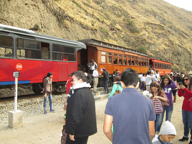
Nariz del Diablo Train in Sibambe, Ecuador

I have a simple plan to cure the ignorance of most Americans who think themselves to be proud because they have lived in the same shithole all their lives. The idea came to me from reading Mark Twain, who wrote in The Innocents Abroad (1868):

Travel is fatal to prejudice, bigotry and narrow-mindedness and many of our people need it sorely on those accounts. Broad, wholesome, charitable views of men and things cannot be acquired by vegetating in one little corner of the earth all one’s lifetime.

Lest we all become too place-proud, we need to send our people to travel in the so-called Third World. And I don’t mean First Class seating on jet aircraft and staying at luxury hotels and ordering room service. I mean forcing them to take buses and trains, struggle with the language, and eat what the ordinary people eat. In every way, such an experience will open their eyes and, when they return to East Jesus, Arkansas, they will be better people for it.

And no, it isn’t an ordeal—not by a long shot! When I first started to travel, I had experience of only four places: Cleveland, Ohio (most of my life to that point); Hanover, New Hampshire (my 4 years at Dartmouth); Los Angeles (eight years at UCLA and after); and Lake Worth Florida (just a few weeks, not counting my infancy). Growing up in the Midwest, we never went anywhere for any length of time. My first whiff of Yucatán not only opened my eyes, my nasal passages, and my taste buds, but I felt I was at the beginning of a more wondrous existence.

Work kept me from traveling as much as I wanted to, but I traveled enough to have many happy memories.


Antigua Guatemala

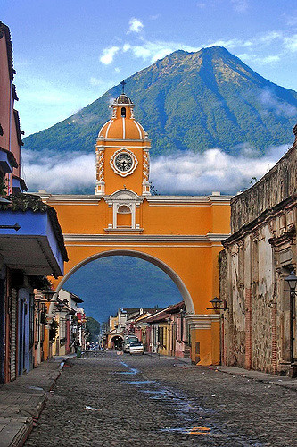
Arco de Santa Catalina and Agua Volcano in Background

If asked what is the capital of Guatemala, it is best to turn your answer into another question: At what point in history? Today, Guatemala City is the capital of Guatemala. In 1524, Pedro de Alvarado founded the Ciudad de Santiago de los Caballeros de Goathemalon [sic], near the present town of Iximche. After a Kaqchikel Maya uprising in 1527, the capital was moved to Ciudad Vieja and retained the same name as the original. In 1541, that city was destroyed by a gigantic mudflow from the Volcano de Agua (illustrated above). Two years later, the capital was moved five miles to the Panchoy Valley to the present city of Antigua Guatemala.

In the 18th century, earthquakes and volcanic eruptions caused one final move, to the capital’s present location. That does not mean that the city of Antigua Guatemala, despite all the ruined churches, is not one of the most popular tourist destinations in the country. In fact, when I go to Guatemala for my vacation, I will take a shuttle directly from the airport to Antigua, about 45 minutes away.

Guatemala City has a reputation of being a big, ugly city with a couple of good museums, but otherwise devoid of major tourist attractions. So, I will base myself in Antigua.

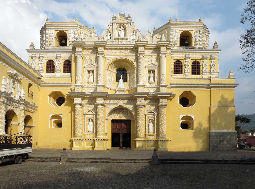
Intact Façade of Nuestra Señora de Merced, Otherwise in Ruins

With Antigua serving as a kind of tourist ghetto, there are a multitude of private shuttles to major tourist destinations—all originating in Antigua. One can treat the town as if it were the capital except for one thing: The airport is in Guatemala City. As Guate, as it is called, is the largest city in Central America, I think it would be more restful to base myself in a well-connected town with a population of only about 50,000.


A Great Travel Resource

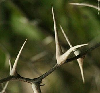
In Australia, Travelers Posted Notes on the Thorns

A few years ago, I was an active member of Bootsnall.Com, which had great postings on travel to every corner of the Earth. Of late, Bootsnall has yielded pride of place to Lonely Planet’s Thorn Tree (though I have hopes they’ll make a comeback). According to Lonely Planet:

Lonely Planet’s travel forum (Thorn Tree) has been a leading online destination for travel enthusiasts and thrill seekers since 1996. It was created as a place for travelers to exchange travel advice, hints, hacks, and tips in order to help them get to the heart of a destination.

Thorn Tree is by travelers, for travelers, and covers every place on the planet including places we don’t have guidebooks for (yet). More than 2 million members have joined the community since its inception and have engaged in conversation with others, while making countless connections, over the past 20+ years.

To get there, click here.

You may recall that, a few days ago, I wrote a post entitled “You Can’t Get There from Here … Not Easily, Anyhow.” I was researching how to visit the Mayan ruins of Tikal, Copán, and Quiriguá, which are not too far from one another as the crow flies—but, alas, I have to take the roads, not crows, to get there. I checked out Thorn Tree, and found out how to get to Copán and Quiriguá easily enough . (Tikal will have to be a separate trip.) This is what the poster wrote:

If you are coming back to Antigua, there are tourist shuttles that stop by Quirigua, another Maya site with the largest stelae in the Maya world. It is small compared to Copan, but if you are already in the area, it is worth the stop. There are no shuttles that stop there on the way to Copan, only on the return.

Thank you, CraigAdkins! I found a number of helpful posts. If you are interested in solving any knotty travel problems, I suggest you give the Thorn Tree a look. And check out Bootsnall.Com as well.

Serendipity: The Name of God

Lithograph by Frederick Catherwood of the Mayan Ruins at Copán, Honduras

It is with the greatest pleasure that I am re-reading a book I first read in June 1975 in preparation for the first of my travels, to the Yucatán Peninsula in Mexico. The book was Incidents of Travel in Central America, Chiapas and Yucatán by John Lloyd Stephens. The book was published in 1841 in two volumes with illustrations by Frederick Catherwood, who accompanied Stephens on his journeys. At one point, Stephens and Catherwood visit a school in Zacapa in Guatemala, where they set about making a usable dictionary of Mayan Indian words. As Stephens recounts:

We were rather at a loss what to do with ourselves, but in the afternoon our host called in an Indian for the purpose of enabling us to make a vocabulary of Indian words. The first question I asked him was the name of God, to which he answered, Santissima Trinidad. Through our host I explained to him that I did not wish the Spanish, but the Indian name, and he answered as before, Santissima Trinidad or Dios. I shaped my question in a variety of ways, but could get no other answer. He was a tribe called Chinaute, and the inference was, either that they had never known any Great Spirit who governed and directed the universe, or that they had undergone such an entire change in matters of religion, that they had lost their own appellation for the Deity.

The two volumes are still in print from Dover Publications.


You Can’t Get There from Here … Not Easily, Anyhow

Maps Can Be So Deceiving

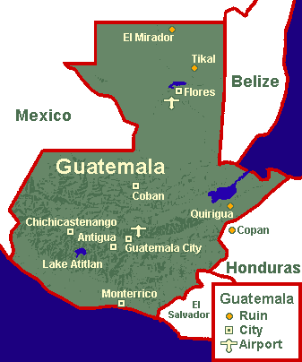
There are three Mayan ruins that I hope to visit on my trip to Central America. You can see all three of them on the above map: Tikal in Guatemala’s Petén Department, Quiriguá in Guatemala’s Izabal Department; and Copán in Honduras’s Copán Department. As the crow flies, the distance separating the three cannot add up to more than three hundred miles. Ah, but tourists do not travel as the crow flies. They must take planes or roads; and in the jungles of Central America, airports are few and roads are not built for the convenience of tourists.

Probably the easiest thing to do is to make three separate trips from Antigua or Guatemala City: to Tikal and back, to Quiriguá and back, and to Copán and back. Take Copán and Quiriguá: They look so close to each other on the above map. But to go by public transport, I’d have to go by way of Chiquimula or Rio Hondo, and probably spend the night at one of those two towns. The buses are mostly for the convenience of the locals, and they just don’t go traipsing between Mayan ruins.

I could probably hire a driver, but there’s this international boundary between Honduras and Guatemala, which complicates things.


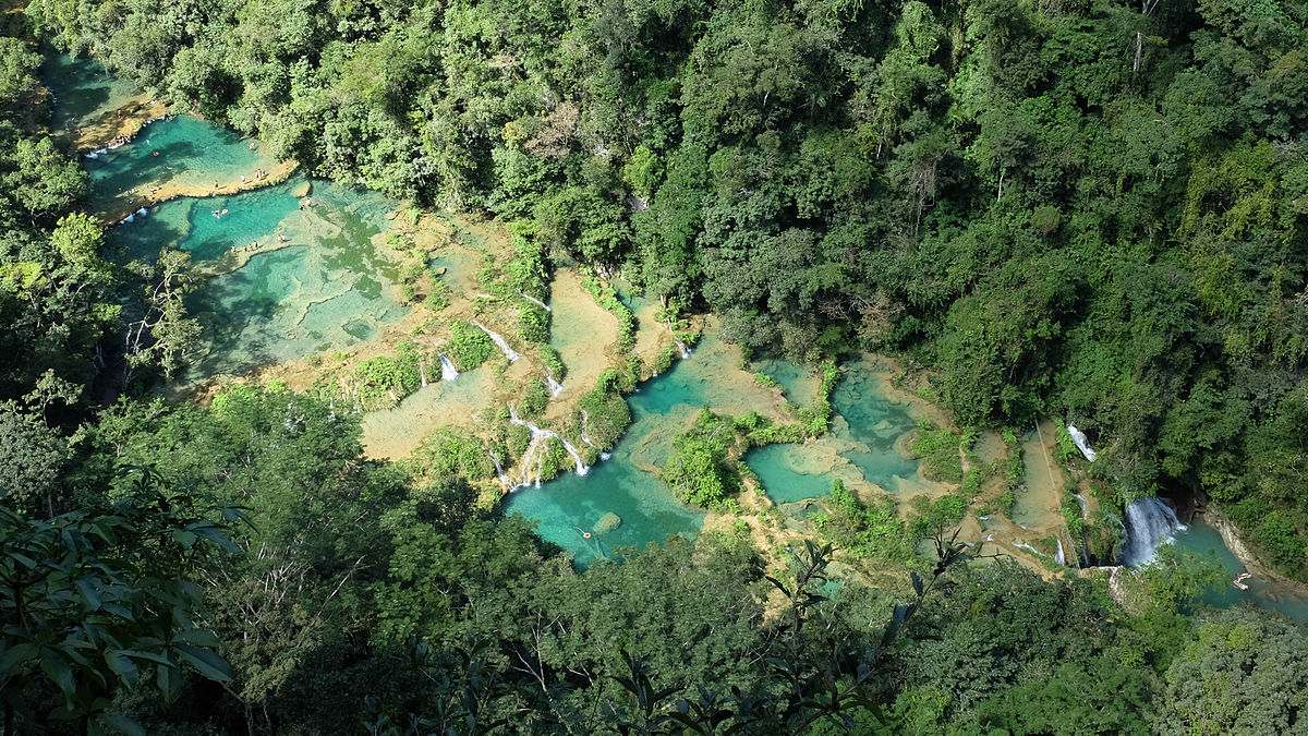
Semuc Champey: “Where the River Hides Under the Stones”

A Land Bridge With Pools Under Which the River Flows

My niece Hilary has been to Guatemala a few years back. When I talked to her a couple of weeks ago, I asked which place impressed her the most. Her answer sent me to the index of my guidebook. It was Semuc Champey in the department of Alta Verapaz. This is what I found in my Moon Guatemala guide from 2015:

A giant, 300-meter-long limestone bridge forms the backbone for the descending series of pools and small waterfalls that makes up Semuc Champey. The water that fills the pools is the product of runoff from the Río Cahabón, churning as it plunges into an underground chasm from where it reemerges downstream at the end of this massive limestone overpass.

One can swim in these pools—it does look refreshing considering the surrounding jungle. There are also trails to a lookout point (from which the above photo was probably taken) and down to another point where the river plunges into an underground cavern. Sounds like Coleridge’s Xanadu:

In Xanadu did Kubla Khan
A stately pleasure-dome decree:
Where Alph, the sacred river, ran
Through caverns measureless to man
Down to a sunless sea.

The only problem is that Semuc Champey is not really on the road to anywhere. My first reaction to that, though, is “sounds like fun.” I may just decide to take my swimsuit and try a dip in the waters.


Looking South to Guatemala

Temple I at Tikal in the Petén

It’s time to resume visiting Mayan ruins, after a hiatus of twenty-five years. It was in 1992 that I went to Yucatán with Martine and several friends from work. For years I had wanted to see the ruins in Guatemala, but there was something like a civil war going on under the dictatorship of Efraín Ríos Montt, whose “Evangelical” regime was slaughtering the Mayans. For most of the 1980s, the U.S. State Department recommended that Americans stay out of Guatemala.

Later this year, I hope to visit the ruins of Tikal and Quiriguá in Guatemala and hop over the border into Honduras to see the ruins of Copán. Half the trip will be devoted to ruins, and the other half to visiting picturesque Highland Mayan towns like Antigua, Huehuetenango, Chichicastenango, and Panajachel. It would be nice if I could talk someone into accompanying me, but even at my advanced age, I am too adventurous for most of my friends.

I am starting my planning early, because I have a lot of reading to do before the rainy season ends in Central America.


The Great God Chac

Chac Masks at Uxmal

From my trips to Yucatán, I became impressed with the one dominant image of Yucatec Mayan art: The face of Chac (pronounced CHOCK), the rain god. You see, Yucatán is a land without surface rivers. Oh, there is plenty of flowing water underground, but none of it breaks the pitted limestone surface of the peninsula. In areas several hundred feet above sea level, such as in the Puuc Hills, the water that sustained the ancient Mayans came from chultunes, underground cisterns. In some years, the cisterns were full; in others, there was pitifully little to sustain the cornstalks that fed the people.

When one visits Yucatán, particularly in Puuc Hill sites such as Uxmal, Kabah, Labna, Sayil, and Xlapak, the dominant image is that of hundreds of Chac masks acting as façades of the Chenes-style buildings.

After the rainy winter Southern California had last year, I was hoping for a repeat, but so far this rainy season, we haven’t received anywhere near an inch, or even a centimeter, of the wet stuff. We have rain forecast for next week, but my fingers are crossed. So often the winds just blow the clouds inland where they go to water the desert.

I am thinking, perhaps, of going to Yucatán again this year. There are a number of Mayan sites I have yet to visit, such as Coba in the State of Quintana Roo and Edzna and Xpujil in the State of Campeche. Despite the heat and humidity of the great limestone block that is the peninsula, it is a fascinating tourist destination, well developed with reasonable accommodations and good food. In addition to Yucatec cuisine, which is quite distinctive with its reliance on achiote, bitter oranges, and Habanero chiles, there are Syrian restaurants (the merchant class of 150 years ago was heavily Middle Eastern), plus the standard Mexican antojitos.

If I go, it will be toward the end of the year, after the rainy season which is also super hot and sticky.


On the MV Lady Rose

A Cruise on the MV Lady Rose in 2004

I am thinking back to a daylong cruise I took in 2004 between Port Alberni on Vancouver Island and Bamfield and back again. The little packet freighter we were on, the MV Lady Rose, is no longer in service, built was a fun ride. The Alberni inlet is a wild place, with dense forests, a few logging camps, lots of wildlife, and very few roads, if any. We saw bears along the edge of the inlet.

Vancouver Island in British Columbia is one of my favorite travel destinations, from Victoria to Nanaimo, Port Alberni, Ucluelet, and especially Tofino. There is one place in Tofino I always wanted to stay. During the month of January, powerful lightning storms assault the Pacific Coast of the island; and the Wickaninnish Inn just south of Tofino is an ideal place to watch all the action. It costs a bundle of money, but it would be worth it.

Failing that, the Tofino area is rich in things to do and places to see, including temperate rainforest hikes, whale cruises, and boat rides to watch bears feeding along the numerous islets surrounding the town.

In the past, I stayed at the Whalers on the Point Guesthouse, a better than average youth hostel within easy walking distance of restaurants and the Tofino Bus stop. (I do not like to rent cars when I am traveling alone.)

Mad About Travel

Crescent Lake Oasis Near Dunhuang, China

Immanuel Kant was a great philosopher, but I have no desire to emulate him. According to an editorial in Philosophy Now:

A curious case, this Kant. They say that travel broadens the mind, but Kant never in his whole life travelled more than ten miles from his home city of Königsberg (now Kaliningrad). He scraped a living for years as a private tutor before eventually becoming a hardworking professor at the university. He lived a life of disciplined regularity, taking the same walk around Königsberg at the same time each day, with such regularity that it was said that the inhabitants set their watches by him.

Living in Cleveland in the 1950s and 1960s, I desired more than anything else to travel. Even when I came out to California and got a job, it was a full seven years before I could afford to go anywhere but Cleveland. And when I did, my parents were appalled. “Why don’t you come to Cleveland?” Mom wheedled. “I’ll cook my favorite dishes for you.” That’s all I needed—to get even fatter.

I started out with baby steps, going to Mexico and traveling all around the country by bus and train (back when there were trains). I went to England and Scotland, too, and even joined my parents in 1977 to visit Hungary and Czechoslovakia.

In 2001, I went to Iceland; and, in 2006, I discovered South America. Now my desire for travel is insatiable. On the left corner of my kitchen table is a collection of travel guides from Lonely Planet and moon. While waiting for my morning paper to be delivered, I can read about the Trans-Siberian Railroad (2 guides), Iceland, Bolivia, Ecuador, and New Mexico while sipping a cup of hot tea.

December 29 is the last day of my working career, so I may not be able to afford some more distant locations; but Mexico and Guatemala continue to beckon. If I should win the lottery (hah!) I will try for the Trans-Siberian Railroad between Moscow and Vladivostok, though maybe diverting through Mongolia to Beijing. I can always dream, can’t I?